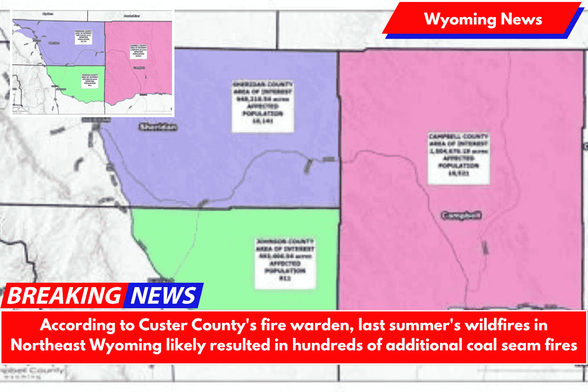
GILLETTE — The 2024 fire season in northeast Wyoming is likely to start hundreds of new coal seam fires in Campbell, Sheridan, and Johnson counties.
The three counties plan to apply for a federal grant to help pay for the mapping of approximately 3 million acres to determine how many coal seam fires exist.
The Campbell County Commissioners were scheduled to consider a joint application for a $1 million FEMA grant, which was administered through Wyoming Homeland Security, at their Tuesday meeting.
County commissioners in Sheridan and Johnson counties will also vote on the application.
The project would map 1.5 million acres in Campbell County north of I-90. It would include everything up to the Montana border. Kristin Young, Campbell County’s deputy director of administration, stated that 1.2 million acres are on private land, 173,000 acres are on BLM land, 96,000 acres are on state land, and 50,000 acres are on US Forest Service land.
It also plans to map 1 million acres in Sheridan County and 500,000 acres in Johnson County. The mapping would take place during the winter, when coal seam fires are most easily mapped.
The county hosted a special meeting last week for landowners and other stakeholders to discuss the grant and the mapping project.
Cory Cheugis, fire warden for Custer County, Montana, spoke briefly about the process he used to map out coal seam fires in eastern Montana. It was a significant issue that had previously been addressed on a case-by-case basis. However, it eventually grew to the point where the strategy needed to change.
He stated that 260,000 acres burned in eastern Montana in 2021, with coal seam fires accounting for 201,000 of the total. It was devastating for agricultural producers, who were the primary economic contributors in that part of Montana.
So the county received a grant to fund the mapping of coal seam fires. Once the mapping was completed, it investigated various mitigation strategies. Counties cannot obtain funding to put out coal seam fires unless they have data to back it up, according to Cheugis.
Cheugis said the Short Draw Fire, which began in northern Campbell County and spread to Montana, burning nearly 35,000 acres, sparked 233 new coal seam fires. These new fires are likely to cause problems in eastern Montana and northern Wyoming in the future, he said.
“That’s 233 unattended campfires sitting out there waiting for a hot windy day to take it away,” Cheugis told me. “The question isn’t if, but when. Unfortunately, the wind usually comes from the northwest, so you’re going to see some fires in the next few years coming in from Montana.”
More than 200 new fires resulted from a single new fire. With the historic wildfire season that northeast Wyoming had, Cheugis said, “I’ll bet you got 1,500 new coal seams burning across these three counties.”
“We need to be proactive instead of reactive,” he told me. “We were reactive for years, which led to our current situation.” You have a fantastic opportunity to get ahead of the game, for the most part, by mapping it out and looking for funding.”
Todd Yeager from the BLM field office in Buffalo stated that his department is “on board here to work together on this to try and find a solution.”
“We will cooperate with the counties, with the private landowners and everybody,” according to Yeager.
Once all of the fires have been mapped, the counties can seek funding to help pay for the firefighting efforts.
“Burying it with a dozer doesn’t really work,” Cheugis admitted. “If it gets any oxygen, it’ll eventually come back.”