Monday Weather
Monday will be warm and breezy with highs in the mid 80s to near 90 degrees. South winds will gust up to 30 mph across the state.
Storms Develop Monday Afternoon and Evening
Scattered thunderstorms will form in western Kansas late Monday afternoon and evening. Some storms could be slightly severe with quarter-size hail and wind gusts up to 60 mph.
Storms Move East Monday Night and Tuesday
Storms will move into central and eastern Kansas Monday night and continue Tuesday morning. Showers and storms will be scattered across much of the state Tuesday morning but will move east by late afternoon.
Possible Severe Storms Tuesday Afternoon and Evening
A few strong storms can’t be ruled out east of the Turnpike Tuesday afternoon and evening. Hail and strong winds are the main threats.
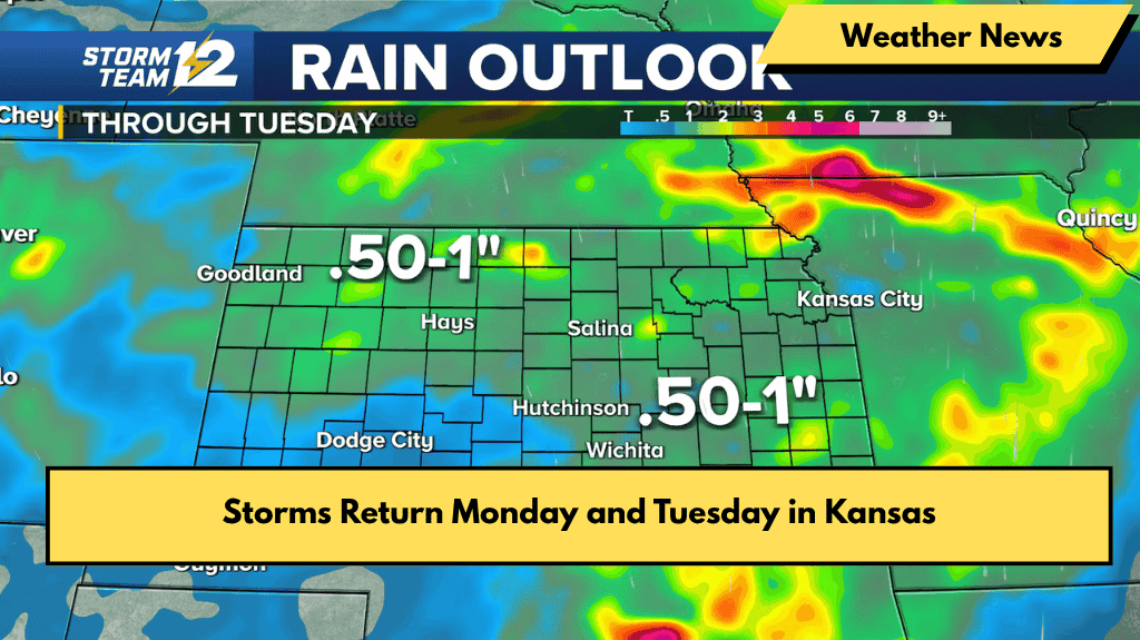
Rain Amounts
Most places will get between half an inch and one inch of rain through Tuesday. Southwest Kansas will get less, generally under a quarter inch.
Active Weather Continues
More chances for showers and storms are expected through the rest of the week and into the weekend.
Wichita Area Forecast
Tonight: Clear, low 62°F, southeast/south wind 5-10 mph
Monday: Increasing clouds, breezy, high 87°F, south wind 15-25 mph, gusty
Monday Night: Scattered showers and storms, low 69°F, south wind 10-20 mph
Tuesday: High 77°F, scattered showers and storms, breezy
Wednesday: High 74°F, low 54°F, partly cloudy with chance of showers overnight
Thursday: High 77°F, low 59°F, chance of morning showers, otherwise partly cloudy
Friday: High 82°F, low 63°F, partly cloudy with chance of storms overnight
Saturday: High 82°F, low 63°F, partly cloudy with chance of storms overnight
Sunday: High 84°F, low 64°F, partly cloudy


