Kathy Jordan, a volunteer at Fort Fred Steele State Historic Site, advised our Lincoln Highway tour group to take our time and watch our step as we descended a steep strip of rock-studded dirt that was once a historic cross-country road in the early 1920s.
The rocks are smooth, rounded, and elevated above ground. Stepping on them causes our feet to bend in two directions at once. The rocks varied in size, from duck eggs to baseballs.
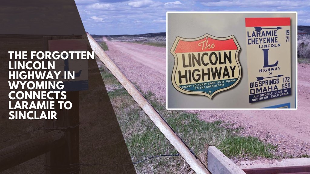
They seemed like an intriguing choice for the country’s first coast-to-coast automobile highway, a 3,000-plus-mile route that began in New York and ended in California.
However, the rocks would have been an improvement for the times. Before the Lincoln Highway was built in 1913, the majority of the country’s roads were simply dirt: bumpy, dusty, and nearly impassable in wet weather.
Carl Fisher, who designed the highway, originally called it the Coast-to-Coast Rock Highway. It was going to cost $10 million to build, even if communities along the route provided equipment in exchange.
He changed the name to the Lincoln Highway to gain support for his vision.
“The Lincoln Highway had so many different routes, and this is only one of them,” Jordan explained as we walked along the narrow stretch of highway turned trail. “And it only existed in Fort Steele from the 1920s until 1939. The town of Fort Steele was destroyed when it was relocated to make way for Interstate 80.
Jordan said that people still unknowingly travel this old section of the Lincoln Highway during the winter. When I-80 is closed and people start looking for an alternative route, GPS directs them to this old stretch of Lincoln Highway.
Then Jordan or another volunteer receives a call when people become stuck.
Because this is an Alliance for Historic Wyoming “Unbarred” tour, we are able to pass through a gate that would normally be locked.
The overall goal is to take people past gates and doors that are frequently off-limits and present slices of rare history with local experts like Jordan.
Our rocky, dirt road quickly gave way to a grassy stretch in a wooded area, which Jordan said is kept up because she receives a lot of calls from tourists wanting to see this section of the old Lincoln Highway. The trail, however, abruptly ends between two pylons that were once part of a Lincoln Highway bridge.
Downed trees and brush lay between the pylons, and beyond that was a head-high sea of meadow stretching into what seemed like infinity.
According to Jordan, winter travelers who take Google’s suggested alternate route rarely make it this far without getting stuck.
Even on a snowmobile, travelers cannot pass through this area.
There is still the river hidden by the meadow to cross, and there is no longer a bridge on this once-great stretch of highway.
Putting Together The Lincoln Highway Pieces
The many pieces and segments of the Lincoln Highway are what Alliance for Historic Wyoming Executive Director Megan Stanfill found most challenging about developing an unbarred Lincoln Highway tour in Wyoming.
This tour from Laramie to Sinclair covered approximately 116 miles of Wyoming and United States transportation history.
Stanfill is a Virginia transplant who enjoys driving race cars with her husband on weekends and researching history in Wyoming. She holds a bachelor’s degree in history. Her affection for the past runs deep.
“When I first moved here, I saw the statue of Lincoln, and I was like, ‘What is that doing here?'” Stanfill recalls.
The 42.5-foot-high memorial statue of America’s 16th president stands above I-80 at the interstate’s highest point on Sherman Hill, just east of Laramie, and commemorates the Lincoln Highway.
Stanfill learned shortly after becoming director of the Alliance for Historic Wyoming that the organization also serves as the state chapter of the Lincoln Highway Association.
“I was, like, that’s why there’s a statue!” Stanfill remembered, chuckling slightly at the memory. “And I thought, ‘We’ve got to do something with this. “This is amazing!”
Stanfill already receives a lot of calls from people wanting to drive the Lincoln Highway, so she sees a lot of potential for a legitimate Wyoming tour.
One of the first things she needs to explain to those who want to drive the entire route is that it is no longer possible.
“There were so many different routes over time,” she explained, holding up an app that shows where the Lincoln Highway is in relation to one’s current location.
Different colored lines represent different iterations of the route. The thickness of those lines indicates whether that section of the highway is still accessible.
In many cases, it is not.
“You can drive through the area where the Lincoln Highway was,” she told me. “And there are lots of places where, if you know what you are looking for, you can see where the highway used to be.”
While driving to Bosler, one of the many dwindling small towns along the old Lincoln Highway route, Stanfll pointed out a two-track that was clearly on private property.
“That’s the Lincoln Highway,” she explained, holding up the app to show how it matched the dirt road.
In other areas, the highway is no longer two-track.
It’s a raised, grassy ledge that runs across a field of reclaimed land that has been converted into a cattle pasture.
Bosler’s Tourist Camps
In Bosler, we stopped at what was once known as a tourist court.
These motor lodge precursors appeared all along America’s fledgling highway system in the 1930s, as more and more people acquired automobiles and began to explore the country on their own.
Stanfill is particularly excited about this piece of Wyoming history, despite the fact that it was created some time after the heyday of the Lincoln Highway, when the United States Numbered Highway System replaced named trails and Lincoln Highway became Highway 30.
Today, the abandoned buildings appear abstract. Dark wood juts up into the sky, free of the white paint that older photos show once covered it.
No trespassing signs have been posted on the building. In an unsuccessful attempt to keep people and animals out, plywood is used to cover windows and other openings, as well as scavenged doorways.
They haven’t stopped a small army of scrawny stray cats from occupying and settling in the tourist camp.
Bosler’s tourist court is one of many historic structures along the old Lincoln Highway that Stanfill believes are in danger of disappearing. Keeping track of vulnerable history is one of the Alliance’s primary missions.
Bosler was established in 1909 near the railroad, primarily on the west side of the tracks. In 1924, it moved east of the tracks to be closer to Highway 30, which was its lifeline at the time.
When it first began as a railroad town, Bosler had big dreams.
Irrigation ditches were planned for “fine cabbage farming,” according to newspapers and promotional materials at the time.
Bosler’s fortunes improved with the construction of the Lincoln Highway in 1913, but declined with the construction of I-80 in the 1950s, which completely bypassed the small town.
The population of Bosler was 264 according to the 1940 census. According to the Alliance for Historic Wyoming, it is now a disappearing dot on the map of approximately ten people.
The Fossil Cabin And Medicine Bow
From Bosler, the Lincoln Highway tour made a brief stop at the original site of Wyoming’s Fossil Cabin, built at the base of the famous Como Bluffs about 5 miles east of Medicine Bow.
Thomas Boylan, who homesteaded the site in 1908, had planned to display a complete dinosaur skeleton there, but after 6,000 bones and many years, he realized he would never be able to do so.
There was no way to determine which bones he possessed, and a scientist who examined them informed him that he lacked all of the pieces required for a complete skeleton.
So, in 1932, Boylan built a cabin out of bones. It weighs an incredible 102,166 pounds, according to Wyohistory.org.
The first large dinosaur skeleton in America was discovered at Como Bluff, and it is still considered legendary in paleontological circles, despite the fact that it is on private property.
Longstanding plans to relocate the cabin to Medicine Bow to protect it from vandalism remain in place.
It will be located near the Medicine Bow Museum and an old grocery store where Owen Wister reportedly listened in on conversations about the Johnson County War while attempting to sleep.
That, in part, inspired him to write America’s first Western, “The Virginian.”
In his novel, Wister portrays Medicine Bow as the epitome of a Wild West town, complete with cowboys and shootouts, schoolmarms and saloons, ranchers and outlaws.
August Grimm and George Plummer built a hotel in 1911, long after Wister first arrived in town in 1885, and named it after Wister’s novel to commemorate a thread of history that had elevated Medicine Bow at the time and made it a popular destination.
Medicine Bow’s future appeared bright when the hotel was built, and a grand, three-story structure with Renaissance Revival architecture seemed appropriate.
The town was then the Union Pacific Railroad’s largest cattle shipping point, sending 2,000 head of cattle to market each day in addition to shipping a variety of other items.
Prospectors looking for gold visited the town as well, stopping to resupply their operations, as did scientists looking for fossils.
However, Medicine Bow’s fortunes followed the fate of the Lincoln Highway, as did Bosler’s, and declined when Interstate 80 was built.
Welcome To Parco, The Wonder Town
Among the newest towns along the old Lincoln Highway Route is the tiny town of Sinclair, built in 1922 by Producers and Refiners Corp. in 1922, when it was seeking an ideal home for a refinery.
The town’s name at the time was Parco, an abbreviation of the company’s name, which was changed to Sinclair in 1943 after Sinclair Oil purchased the refinery.
Parco began as a company town, but not your typical one.
Oil magnate Frank Kistler wanted his employees to feel a sense of pride and community, so he commissioned Fisher and Fisher, a well-known Denver architecture firm, to design a “wonder town.”
Fisher and Fisher designed all of the town’s buildings in a Spanish mission style, arranging them around a central plaza and fountain. The homes were laid out in an orderly grid pattern, which they believed would be conducive to the future growth that a boom town would require.
The majority of Parco’s original buildings have survived, and some still bear the name “Parco”. However, the town never really expanded, and Kistler was forced to sell his holdings in 1934, when crude oil reached an all-time low of 10 cents per barrel.
Sinclair, which purchased the refinery, would play a critical role in fueling America’s aviation dominance during World War II, and it is still one of the most significant and technologically advanced refineries in the Rocky Mountain region.
The town eventually transformed from a company town to an independent town, with the homes sold to residents in the 1960s.
According to residents, the small town’s fortunes have also suffered as a result of Interstate 80, with motorists bypassing it for larger stops along the way. Businesses have closed down. Around a decade ago, the town lost its school and library.
The Parco Theatre, which closed in the early 1970s, has been preserved as a source of hope for the future.
The theater reopened in late 2024 to commemorate Sinclair’s 100th anniversary, with a fully restored stucco exterior and an updated seating capacity of 200.
It’s evolved into a community center, with a calendar full of activities for the community ranging from movies and plays to concerts and comedies.
Hanna, The Town That Coal Built
One of the biggest towns left along the old Lincoln Highway route is Hanna, population 660, founded in 1889 by the Union Pacific Coal Co.
The town’s name honors Mark Hanna, an Ohio politician and businessman who also served on Union Pacific’s board of directors.
The coal fields in nearby Carbon, a ghost town, were deteriorating. Hanna came to visit a potential new coal field in 1888 and became a staunch supporter of establishing a new town nearby. As a result, the town was named in his honor.
Hanna has a big dream that they would like to realize along the Lincoln Highway. That is the restoration of an old gas station that once stood along the route.
“We have all of the ingredients for an original Lincoln Highway station in storage,” historian Nancy Anderson, who lives in Encampment but works on projects in Hanna, told the tour group.
This includes an intact gold crown, which was common among all Standard Oil stations at the time.
The station was located at the Coyote Spring service station, Anderson stated, displaying a photo of a dilapidated wooden structure.
“This crown is really pretty classy, isn’t it, for such a rather primitive kind of building,” she mused. “A family lived at Coyote, no electricity — and it’s hard for us to imagine — raising a family of five.”
The station had a small meeting room with an Atwater Kent radio that coal miners could use to hear what was going on in the world at the time, such as Joe Lewis fights.
“It was very much the center of the community,” Anderson explained. “And this was about 1935.”
Paperwork from the station from World War II reveals that the station had an inventory of 2,000 cigarettes and that the family also raised milk cows for a living.
“They sent the cream to Denver to be made into butter, and they dug wells,” Anderson told me. “They had sheep and made a very poor living.
“But when you talk to the family, it was a glorious growing up out here in the middle of nowhere.”
Future Tourism Awaits
Anderson is among those who hope the Lincoln Highway Association will start to focus on developing experiences along the route, pointing to the marketing success of Route 66, which has been promoting road trip sites to historic locations along the 1926 route for decades.
Anderson believes the Lincoln Highway is more significant than Route 66 because it was America’s first coast-to-coast highway.
It was also the highway that inspired President Dwight Eisenhower to advocate for a national network of highways after traveling on it in 1919 to see if the country’s roads could handle motorized army vehicles.
“This was called the Mother Road,” Anderson explained. “And it has recently been rediscovered for its value as far as history and its value as a tourist attraction.”
Gas station restorations along U.S. 66 have been popular, Anderson said, citing the Hackberry General Store in Arizona, which has been preserved in all its “rusticity.”
“I think what a wonderful idea for the Lincoln Highway in Wyoming,” she told me. “To be interested in not only a film or a picture, but to actually be able to visit a building.”
The pieces of that vision are all waiting to be realized, a vision that only requires a small amount of funding to keep the spirit of the old Lincoln Highway alive.