Following heavy rainfall in the last week of May, June has begun much more quietly across South Texas. San Antonio has yet to receive any measurable rainfall this month, and we are now 2.13 inches below average for the year.
However, the weather pattern is about to get more active again. High pressure, which had kept us hot and dry over the weekend, is beginning to move away from the area.
It will be replaced by a low pressure system moving in from the west, as well as a weak cold front draped across the state. What are the results? Rain and slightly cooler temperatures are on the way.
San Antonio’s forecast timeline
Monday: A weak cold front will move into Central Texas on Monday morning, but it will stall before reaching San Antonio, resulting in another hot and humid day across the region.
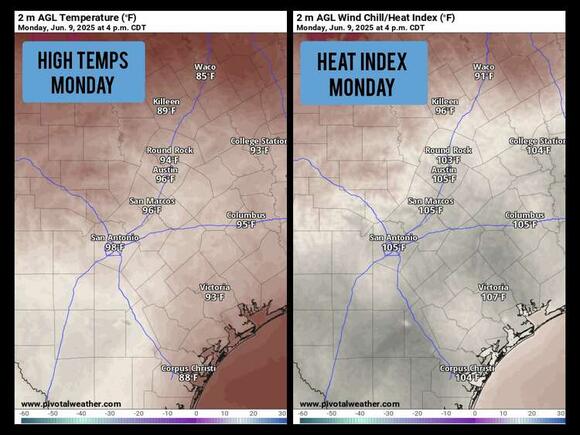
Monday will begin with mostly cloudy skies and morning low temperatures in the mid to upper 70s. Temperatures will steadily rise throughout the day, reaching 90 degrees by noon and peaking around 98 degrees by late afternoon. That is about 5-7 degrees above the average for early June.
High humidity will make things feel worse outside. Afternoon heat index values are expected to peak between 103 and 107 degrees. If you have to be outside for an extended period of time, stay hydrated and take frequent breaks away from the sun. An isolated storm cannot be ruled out in the evening, but rain chances are only around 10%.
Tuesday: The weak cold front will continue to meander southward, lowering temperatures in San Antonio by a few degrees. Still, high temperatures will be warm, reaching 95 to 96 degrees.

Scattered thunderstorms will also increase in the afternoon and evening, reaching around 30% for the San Antonio metro area. A few storms could be strong to severe, producing large hail and damaging winds.
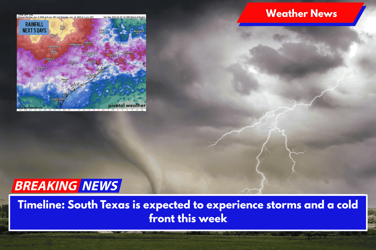
Wednesday and Thursday will be the rainiest days in South Texas, with a 40 to 50 percent chance of thunderstorms each. It should be noted that we don’t expect to see rain all day. Rather, long periods of dry weather will be punctuated by brief bursts of heavy rain.
Once again, a few severe thunderstorms are possible, with large hail and damaging winds the main threats.
Temperatures will begin to drop more significantly. High temperatures in San Antonio are expected to reach the low 90s on Wednesday and Thursday, according to weather models. If particularly heavy rainfall occurs, highs may remain in the 80s for some time. Morning lows will remain mild, hovering around the mid-70s.
How much rain has fallen this week?
There is still a lot of model uncertainty about how much rain we’ll get. The most likely scenario is that San Antonio will receive 1 to 2 inches of rain.
Isolated higher amounts are possible in areas hit by the most powerful storms. A few areas in Central and South Texas could receive more than 2-3 inches of rain, potentially causing flash flooding. Stay tuned to expressnews.com/weather for daily forecasts throughout the week.


